Things I do
I ask people to draw maps...
· Draw the World
· Draw Europe's nations
· Crowdsourced Continent maps
I make map cards:
· See map cards
Other things I wrote about:
· Little moments from travel
· London art & museums
· Football with foreign fans
· London shop geography
About this blog
I also write a newsletter about museums.
Crowdsourced Continents: The World
Friday, October 30, 2015I went to a Latin American festival, Canada Day and USA Independence Day events, a UK / Australia cricket match, a European folk music festival, an African Craft Fair and a variety of Asian events.
At each, I asked people at the event to draw a map of that event's continent. Some people came from the continent, some from elsewhere.
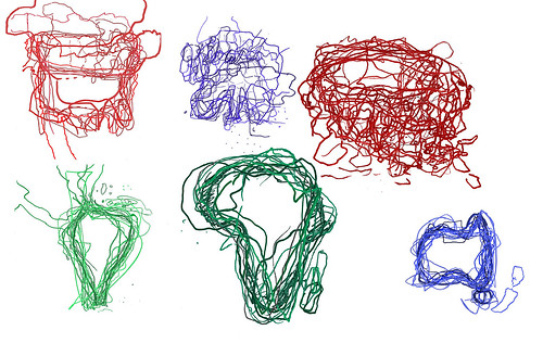
I then took all these maps and laid them on top of each other to create a jumbly mind-memory-map of these continents. And here are all those maps, as the world.
Some were clear - Africa, Australia, South America - and some much less so - Europe and Asia.
In all, we can see that maps are made by drawing, constructs in the moment, made from memory which is patchy and personal, familiar and fascinating.
I've had really interesting conversations with the 87 people who drew these maps, and hopefully, you enjoy them too.
Labels: Africa, Asia, Australia, cartography, Europe, hand-drawn, iaskpeopletodrawmaps, map, maps, multimapped, North America, South America
Sketching North America
Monday, July 04, 2011It's been a while (2 years) since I went collecting continent maps at London festivals. I've decided I want to collect the world, so this weekend I went in search of North America.
Eleven people drew maps, and here they are all over-laid.
On Friday, I went to Trafalgar Square for Canada Day celebrations. There was hockey, mounties, beer and curly fries. It was all very good fun, with people wearing red and maple leaves all over. The 6 people who drew maps for me were fun and friendly.
On Sunday, I searched out 4th of July celebrations. The first event I went to (in Portman Square) was a bit too private, so instead I then went to King Edward Memorial Park where I expected to find a big American picnic.
The turn-out was in fact smaller, but 5 people obliged me. One man had a flag on his hat. Swell!
So, thanks to Alisha, Jen, Jo and Lauren from Canada, Amy, Jessica, Jon and Tim from the USA, Christina and Grem who are English, and Izzy who is English (and Austrian too). Here are their maps individually:
Labels: Canada, cartography, hand-drawn, iaskpeopletodrawmaps, map, multimapped, North America, USA
