Showing posts with label maps. Show all posts

Crowdsourced Continents: The World

Friday, October 30, 2015

Crowdsourced Continents: The World
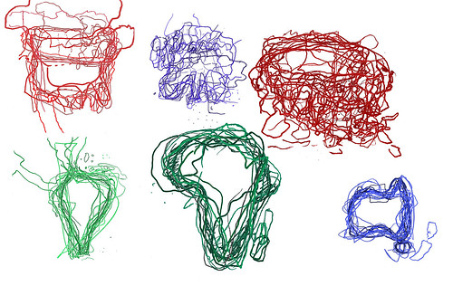
For the past few years, I've been going to events in London asking people to draw maps of continents.

I went to a Latin American festival, Canada Day and USA Independence Day events, a UK / Australia cricket match, a European folk music festival, an African Craft Fair and a variety of Asian events.

At each, I asked people at the event to draw a map of that event's continent. Some people came from the continent, some from elsewhere.

I then took all these maps and laid them on top of each other to create a jumbly mind-memory-map of these continents. And here are all those maps, as the world.

Some were clear - Africa, Australia, South America - and some much less so - Europe and Asia.

In all, we can see that maps are made by drawing, constructs in the moment, made from memory which is patchy and personal, familiar and fascinating.

I've had really interesting conversations with the 87 people who drew these maps, and hopefully, you enjoy them too.
Crowdsourced Continents: Asia

Thursday, October 22, 2015

Since 2009, I have been (on-and-off) asking people to draw maps of continents which I then overlay on each other.

I've asked people to draw South America, Australia, North America, Europe and Africa.

But I've waited a long while to 'do' Asia. Mainly as I didn't know how to approach Asia.

I had previously asked people at a SouthEast Asian festival to draw some maps, could I follow that idea with more regions. Should I divide Asia into regions and, if so, which regions?

The answer had been staring me in the face rather obviously: ask people to draw 'Asia' - a seemingly simple but complex challenge.

In August and September, I went to a variety of events where I asked people to draw Asia:

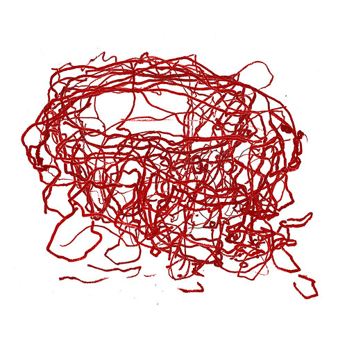
I met people at these events who I asked to draw Asia. And I also asked a few friends who have connections to Asia. So here is the result.


Sketched Asia
It's quite a tangle of lines, shapes, places. Asia seemed to be a difficult concept for the people I asked: where does it start and end? where does it include? 

Many people only drew their own country. 

Thanks to: Phuong, Alex, Darren, Aaron, Kris, Koa, Ekta, Hang Catie, Shuk Kwan, Raj, Suraj, Mohammad, Tina, Jeff, Sultan, Keejung, Niie, Dana, Chris and Taemin for humouring me and drawing a map.

Here are their maps individually.


And that is my last crowdsourced continent map: in my next blog, I'll show all the continents together.

Africa, sketch maps

Monday, June 02, 2014

I've resumed collecting crowd-sourced* 'multi-maps'.

*when I first started asking people to draw maps, crowd-sourcing wasn't a popular term but it is now and works well.

Previously, I've collected maps of North America, South America, Australia, South East Asia and Europe.

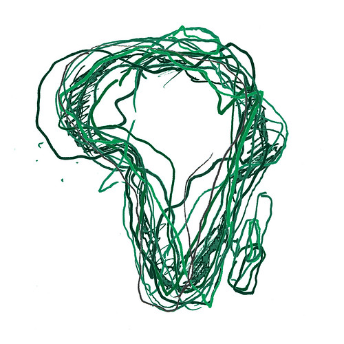
This time, I looked for maps of Africa.

I went to an African Market in Spitalfields to ask stallholders, shoppers and spectators to draw Africa.

I asked twelve people to draw Africa. I've overlaid these maps on top of each other. This is the result.

Africa, sketched

Country and map prints

Wednesday, May 07, 2014

Every time I've sold my map cards and notebooks at a craft fair, someone has told me that I should make prints of them too.

So I've given it a go.

I'll be selling these below (and more) at the craft fair at Balham Bowls Club next Sunday 11 May from 12-6pm.

Come say hello!